Navigation
Install the app
How to install the app on iOS
Follow along with the video below to see how to install our site as a web app on your home screen.
Note: This feature may not be available in some browsers.
More options
You are using an out of date browser. It may not display this or other websites correctly.
You should upgrade or use an alternative browser.
You should upgrade or use an alternative browser.
A Spring Pick Me Up
- Thread starter Bob
- Start date
b.stark
Forever Wandering
- Joined
- Apr 8, 2015
- Messages
- 1,082
@Bob heres a trip report from the hike where that pic was taken: https://backcountrypost.com/threads/wind-river-range-2009-from-the-vault.8360/
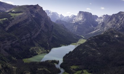
Here are a couple photos. Elbow from above to the East

This is I think an unnamed lake between elbow and the golden lakes. Took this as we walked past Elbow.

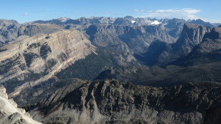
This is looking back at elbow lake from the Plateau that is Lost Eagle Peak

We dropped straight down to Slide Lake from the saddle between Lost Eagle and White Rocks. I think the better way is to follow the white rock ridge and eventually meet up with the slide lake trail, but what we did worked. Maybe it's equal difficulty either way? The views from Lost Eagle were incredible.
Here are a couple photos. Elbow from above to the East

This is I think an unnamed lake between elbow and the golden lakes. Took this as we walked past Elbow.

This is looking back at elbow lake from the Plateau that is Lost Eagle Peak

We dropped straight down to Slide Lake from the saddle between Lost Eagle and White Rocks. I think the better way is to follow the white rock ridge and eventually meet up with the slide lake trail, but what we did worked. Maybe it's equal difficulty either way? The views from Lost Eagle were incredible.
Last edited:
OldBill
Member
- Joined
- Aug 18, 2015
- Messages
- 457
From a post by Wandering Daisy (aka Nancy Pallister):
Our goal for the day was to find the use-trail that is Finis Mitchell’s route. The use-trail starts at a meadow more than 500 feet elevation below Slide Lake. We first tried to short-cut and traverse ending in hideous talus so we returned to the trail and dropped to the place where Slide Creek sinks into the ground and crossed. After some traversing through soaked brush and following disconnected game trails, we finally intersected a fair use-trail that continued upward nearly 2,000 feet to the saddle between Lost Eagle Peak and Pt 11245. A narrow ridge continued up another 600 feet. We impatiently tried to cut across after 400 feet of gain, only to admit defeat and return upward to the flat top plateau of Lost Eagle Peak, where we found cairns that lead us back to the use-trail dropping down due south following a small creek. Stopping, we went to the edge and peeked over to see Elbow Lake #2 below a 600-foot cliff. The trail continues south to a narrow grassy bench nearly level with the lake. We turned east to the outlet finding an established campsite. Weather looked threatening, so we decided to camp after only 3.5 miles, instead of continuing to Golden Lakes, our original destination. All we could say was that if Finis Mitchell rode his horse to Elbow Lake #2, he was quite a horseman! The threatening weather never materialized so I walked to the other end of the lake and my friend worked on his pika data (he was doing a voluntary pika location study for some internet research project). I looked intensely towards Golden Lakes, wondering how were going to get there; it appeared like we would be stopped by cliffs.
Our goal for the day was to find the use-trail that is Finis Mitchell’s route. The use-trail starts at a meadow more than 500 feet elevation below Slide Lake. We first tried to short-cut and traverse ending in hideous talus so we returned to the trail and dropped to the place where Slide Creek sinks into the ground and crossed. After some traversing through soaked brush and following disconnected game trails, we finally intersected a fair use-trail that continued upward nearly 2,000 feet to the saddle between Lost Eagle Peak and Pt 11245. A narrow ridge continued up another 600 feet. We impatiently tried to cut across after 400 feet of gain, only to admit defeat and return upward to the flat top plateau of Lost Eagle Peak, where we found cairns that lead us back to the use-trail dropping down due south following a small creek. Stopping, we went to the edge and peeked over to see Elbow Lake #2 below a 600-foot cliff. The trail continues south to a narrow grassy bench nearly level with the lake. We turned east to the outlet finding an established campsite. Weather looked threatening, so we decided to camp after only 3.5 miles, instead of continuing to Golden Lakes, our original destination. All we could say was that if Finis Mitchell rode his horse to Elbow Lake #2, he was quite a horseman! The threatening weather never materialized so I walked to the other end of the lake and my friend worked on his pika data (he was doing a voluntary pika location study for some internet research project). I looked intensely towards Golden Lakes, wondering how were going to get there; it appeared like we would be stopped by cliffs.
OldBill
Member
- Joined
- Aug 18, 2015
- Messages
- 457


