Amazing Discovery in Utah-Glen Canyon

If anyone would like to PM me, I will provide the coordinates.
Obviously this is 2022 and unfortunately, there is not much left to discover in this world, so I’m trying not to go completely off the rails with what-if scenarios; and those who I have spoken to can correct me if I’m wrong. But in talking to a few people familiar with the area, trails, etc.; I took a deeper look at it again on the map, in regards to terrain. I think it is very safe to say, that no one has been to this spot in a very very long time. I would compare if you were to hike a full day, away from the most remote trail of the grand canyon (into the canyon).
Having said that, if you knew where to cross the lake from Halls Crossing, and could find a place to make it up the bank; ironically, it would not be nearly as difficult to get to…
I PMed you for coords. Any reason you haven't responded?
 
Obviously this is 2022 and unfortunately, there is not much left to discover in this world, so I’m trying not to go completely off the rails with what-if scenarios; and those who I have spoken to can correct me if I’m wrong. But in talking to a few people familiar with the area, trails, etc.; I took a deeper look at it again on the map, in regards to terrain. I think it is very safe to say, that no one has been to this spot in a very very long time. I would compare if you were to hike a full day, away from the most remote trail of the grand canyon (into the canyon).
Having said that, if you knew where to cross the lake from Halls Crossing, and could find a place to make it up the bank; ironically, it would not be nearly as difficult to get to…
I PMed you for coords. Any reason you havent replied?
 
This is going to be sort of a rambling, spitballing thoughts thread, like I said I am in Michigan, it’s winter and I am bored out of my mind lol.

Anywayyy, from what looks to be the closest accessible location (via water from Halls crossing), it would be a 2 mile hike. If you were to cross directly from halls crossing, it would still be a 6.5 mile trek, assuming you could get up the bank.
 
IMO after looking at it on GE ( using historical images ) it doesn't look man made. It just looks like a sandstone pattern. There are other similar patterns in the area.
 
IMO after looking at it on GE ( using historical images ) it doesn't look man made. It just looks like a sandstone pattern. There are other similar patterns in the area.
Definitely could be nothing. Just thought it would be a cool adventure for the local experts. I’m hoping someone can get out there safely and get some pictures.
 
Ok, looking again, it would actually be a ~40 mile boat ride from Halls crossing, to the closest canyon. Going straight across from Halls canyon to Lost Eden Canyon, would be the only route. Assuming you could get up the bank there, it’s a 4.2 mile hike…
 
None of the mileages you indicate are extreme .... Thousands of boaters and many hikers abound ... Not so much now the lake is way low ..... But. Interesting though.
 
You said something about the closest marker on the map was Halls Crossing? Maybe you know, that is one of the hearts of Lake Powell, as far as visitation. Any canyon accessible from the lake in that area would have a wide "variety" of people camping and hiking there since the 70s. Lake levels too would have made some areas much more accessible than today... a few maybe less.

I am interested in where.
Anywhere that would have to be accessed by lake would be a solid no during winter.

As an example of what people do...In Escalante there is this thing.... visible in GE and recently improved last time I was there. Someone spent a lot of time moving around lava boulders. I hope they were not trying for 69, instead of 96...
View attachment 116939
Would love to share the coordinates with you and get your thoughts.
 
None of the mileages you indicate are extreme .... Thousands of boaters and many hikers abound ... Not so much now the lake is way low ..... But.
Annie’s Canyon, would be the easiest route. Looks like you could easily and safely land a craft, and then it’s just a 2 mile hike…
 
Annie’s Canyon, would be the easiest route. Looks like you could easily and safely land a craft, and then it’s just a 2 mile hike…

I am happy to look, just PM me. I will check back after USA v Iran.

Lake level is around 3550' +/- right now. I was in Annie's this summer, and for sure one arm ends in a dryfall, and I am not sure if we went up the other, but the levels being so low means the head of any of these canyons are usually a tangle of cottonwood skeletons.
As well, just 10-20' of lake level can put you above or below an impassable dryfall.
 
Why not contact the park or BLM archaeologist in that region?

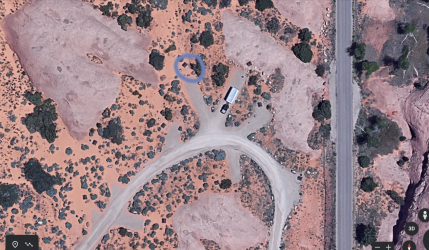
I know of a similar carving that looks Incan in the Sand Flats Rec Area near Moab. Very well done. In campground A if you're interested, and of course, it's recent.

Screen Shot 2022-11-29 at 10.17.50 AM.png
 
Why not contact the park or BLM archaeologist in that region?

I know of a similar carving that looks Incan in the Sand Flats Rec Area near Moab. Very well done. In campground A if you're interested, and of course, it's recent.

View attachment 116944
That is awesome! Recent as in Native American, or recent as in someone made it look like an Incan/Native American carving? I did reach out to the Glen Canyon GPS Instagram account, but haven’t heard anything back.
 
And looking closer at your GE photo, I think it's natural. First, it's too high off the ground for a casual boater/hiker to carve w/o some difficulty. Also large enough it would take some effort. The Anasazi/Ancestral Puebloans used ladders, which have been found intact in the canyons by archaeologists, and I think this would take a ladder. But again, contact the local archaeologists. If it's legit, odds are very high someone has reported it to them and they know all about it. As an archaeologist (when employed), I have some contacts down there, but I'm hesitant to name them, as they never appreciate wild goose hunts, which I hate to say, I suspect this would be.
 
That is awesome! Recent as in Native American, or recent as in someone made it look like an Incan/Native American carving? I did reach out to the Glen Canyon GPS Instagram account, but haven’t heard anything back.
Recent as in the last 10 years, as I noticed when it first appeared (used to hike there a lot). The Sand Flats team is very aware of it and consider it vandalism, but it is actually kind of cool.
 
And looking closer at your GE photo, I think it's natural. First, it's too high off the ground for a casual boater/hiker to carve w/o some difficulty. Also large enough it would take some effort. The Anasazi/Ancestral Puebloans used ladders, which have ben found intact in the canyons by archaeologists, and I think this would take a ladder. But again, contact the local archaeologists. If it's legit, odds are very high someone has reported it to them and they know all about it. As an archaeologist (when employed), I have some contacts down there, but I'm hesitant to name them, as they never appreciate wild goose hunts, which I hate to say, I suspect this would be.
Thanks for the response, I really appreciate it. And yes, that is why I did not want to mass release the coordinates. I wanted to be an Archaeologist going up, so I have a lot of respect when it comes to the sites/history. I’m just hoping a local might be able to get out there safely and put my suspicions to bed…
 
I hope you don't regret not following your dream, as jobs are pretty scarce. I'm chronically unemployed, which I generally enjoy a lot except for the money part.
 
I hope you don't regret not following your dream, as jobs are pretty scarce. I'm chronically unemployed, which I generally enjoy a lot except for the money part.
Lol. If I regret anything, it would be not getting into coding/programming. Seems like the new Doctors of today…
 
There are landing strips in the area. Some have hangers where people house planes. People take flights to specifically view the area and geology. In the general area in the spring I saw two med flight helicopters airlifting people from house boats. All to say low flying air traffic is not new or infrequent to the area, someone not noticing an authentic man made prehistoric feature that can be viewed from satellite imagery seems unlikely. But if someone is going to take up the hike it would be fun to know what they see on the ground.
 
There are landing strips in the area. Some have hangers where people house planes. People take flights to specifically view the area and geology. In the general area in the spring I saw two med flight helicopters airlifting people from house boats. All to say low flying air traffic is not new or infrequent to the area, someone not noticing an authentic man made prehistoric feature that can be viewed from satellite imagery seems unlikely. But if someone is going to take up the hike it would be fun to know what they see on the ground.
Exactly. I was just hoping a local hiker might know a safe way to get in a take a look. I have seen things on GE before that look crazy and end up being nothing, but this area looks to be so remote, even though Halls Crossing, Lake Powell Marine, etc. are right there. The more I look at GE, there are probably only two routes that are feasible, both assuming you could make it up the back at those locations (Lost Eden Canyon or Annie’s canyon)…
 
Back
Top