mike_offerman
Member
- Joined
- Feb 8, 2012
- Messages
- 546
I headed out to the West side of the Indian Peaks Wilderness, looking to climb my last 2 peaks in the wilderness, Hopi and Cherokee peaks. For those that don't know, the Indian Peaks is a continuation of the peaks to the South of Rocky Mountain NP. There are 37 peaks in the wilderness, and after many years, these were the two that I had left. There is no easy way into them. I figured it was going to be a 17 mile, 6k day.
With a great forecast, we made the 2.5 hour drive over to the West side of the divide. The parking lot was fairly full when I arrived at 6:30. The first couple of miles up to Crater Lake are fairly flat, and then starts to climb a bit before getting to the lake. Crater Lake is amazing, and a major destination for backpackers. We ate a bit at the lake and enjoyed the view. Soon enough we headed North toward the East ridge of Cherokee where we paid the price for the easy hike in on a trail. We now were only half a mile from the peak, but it was over 1,800 feet above us. The terrain was mixed grass ledges and cliff bands. The sun was beating down on us and it was fairly warm for as early as it was and being at 11k. When we topped out of the ridge, we made our way to the East end of the ridge and enjoyed the huge views over to the divide. After another rest, we headed back to the West and climbed the remaining 500' to the top. I was surprised to run across another hiker on the way up. We talked for a while then headed up and summitted at 12:30. We sat there for a long time enjoying the 360 degree views. Our plan was to descend a south western gully, but after taking a look at it, we found it full of hard snow. We were not prepared for this, and after looking around at different alternatives, we decided the only way down was the way we came. This would drop us well below where the gully would have taken us, plus we were now on the wrong side of the peak to climb unranked Mount Achonee and the easy ridge over to Hopi. Once we were down to where we could traverse toward Hopi, I knew that it was going to happen. We were still looking at another 2k vertical over rough terrain. We threw in the towel and headed back down the trail we had come up. It was a long way back out, but with the trail next to a nice roaring creek and a few moose along the route, we got back to the car at 5:20. We still ended up hiking over 17 miles and 5k vert.
Am already planing my next trip in to hike Hopi. There is a long traverse from the East that will allow me to drive less to the trail head, and hopefully climb a couple of other unranked peaks along the way.
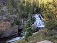
Cascade Creek
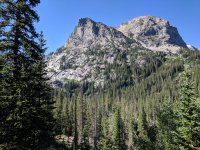
Cherokee Peak on the right, with the East ridge viewpoint in the center. We came up the opposite side.
Apache Peak on the left, Lone Eagle center.
The classic view of Lone Eagle Peak with Hopi behind to the right.
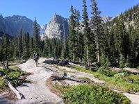
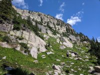
Lots of grass and cliffs on the hike up from Crater Lake.
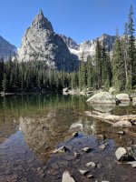
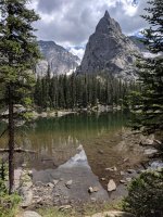
Crater Lake, with Apache, Lone Eagle and Iroquois from left to right.
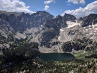
Heading back down to the lake. Soshoni, Lone Eagle and Iroquois above.
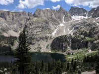
One last view of Lone Eagle before heading down the trail.
With a great forecast, we made the 2.5 hour drive over to the West side of the divide. The parking lot was fairly full when I arrived at 6:30. The first couple of miles up to Crater Lake are fairly flat, and then starts to climb a bit before getting to the lake. Crater Lake is amazing, and a major destination for backpackers. We ate a bit at the lake and enjoyed the view. Soon enough we headed North toward the East ridge of Cherokee where we paid the price for the easy hike in on a trail. We now were only half a mile from the peak, but it was over 1,800 feet above us. The terrain was mixed grass ledges and cliff bands. The sun was beating down on us and it was fairly warm for as early as it was and being at 11k. When we topped out of the ridge, we made our way to the East end of the ridge and enjoyed the huge views over to the divide. After another rest, we headed back to the West and climbed the remaining 500' to the top. I was surprised to run across another hiker on the way up. We talked for a while then headed up and summitted at 12:30. We sat there for a long time enjoying the 360 degree views. Our plan was to descend a south western gully, but after taking a look at it, we found it full of hard snow. We were not prepared for this, and after looking around at different alternatives, we decided the only way down was the way we came. This would drop us well below where the gully would have taken us, plus we were now on the wrong side of the peak to climb unranked Mount Achonee and the easy ridge over to Hopi. Once we were down to where we could traverse toward Hopi, I knew that it was going to happen. We were still looking at another 2k vertical over rough terrain. We threw in the towel and headed back down the trail we had come up. It was a long way back out, but with the trail next to a nice roaring creek and a few moose along the route, we got back to the car at 5:20. We still ended up hiking over 17 miles and 5k vert.
Am already planing my next trip in to hike Hopi. There is a long traverse from the East that will allow me to drive less to the trail head, and hopefully climb a couple of other unranked peaks along the way.
Cascade Creek

Cherokee Peak on the right, with the East ridge viewpoint in the center. We came up the opposite side.

Apache Peak on the left, Lone Eagle center.

The classic view of Lone Eagle Peak with Hopi behind to the right.

Lots of grass and cliffs on the hike up from Crater Lake.

Crater Lake, with Apache, Lone Eagle and Iroquois from left to right.

Heading back down to the lake. Soshoni, Lone Eagle and Iroquois above.

One last view of Lone Eagle before heading down the trail.

