Tres Westbrook
Member
- Joined
- Feb 10, 2013
- Messages
- 122
My wife and I spent the week after Christmas exploring parts of Death Valley National Park in California. I had planned a "highlights" tour of the park, with us doing a day hike or back country drive each day. We spent our first night at Texas Spring campground. It was chilly and windy, but once the tent was set up and tied down (to some fairly hefty rocks), we stayed comfy and warm in our sleeping bags.
The next morning, our first full day in the park, we got up and headed to the Golden Canyon trail head. The hike up Golden Canyon to the Red Cathedral is one of the more popular hikes in the park. A graded dirt road takes you right to the mouth of the canyon.
One of the reasons I enjoy hiking is to achieve some level of solitude. I am not antisocial, but getting away for everything allows my head to reset. Because the Golden Canyon hike is so popular, we had no chance of any real solitude. However, as with most hikes, as we got further down the trail the swarms thinned out. In fact, once we got off the Golden Cathedral trail, we had several stretches where we were seemed to have the whole canyon to ourselves.
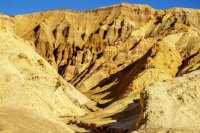
Although Golden Canyon ends at the Red Cathedral, the hike can be extended into a loop by cutting across the badlands, catching Gower Gulch and following its drainage back to the valley. The hike takes you under Manley Beacon, which is the subject of numerous photographs take from Zabriskie Point, before it hooks up with the Gower Gulch drainage. The total length of the hike was about 5.5 miles, with only a few hundred feet of total elevation change. Not a difficult hike by any means, but very scenic.
It was a nice little warm up hike to get us going. Though the weather was chilly, we had a great time walking through the ancient multicolored rock formations.
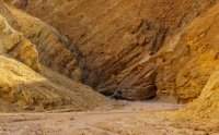
Golden Canyon goes back about a mile and a quarter from the valley. The first mile is a fairly easy walk up the wash through some minor narrows cut from gorgeous golden rock.

The rock has all kinds of minerals in it, including iron. Iron can cause several colors in the rock. In this case, it is green.

I think Borax causes this whitish color.

View up Golden Canyon.

Another rock with all sorts of minerals in it.

Looking back towards Death Valley and the Panamint Mountains on the west side of the valley about 15 miles away.

The Red Cathedral from Golden Canyon.

Manley Beacon from Golden Canyon. It is one of the most photographed features of Death Valley. About a mile on the other side of the outcrop is Zabriskie Point, where tourists entering Death Valley can get their first views over the badlands into the valley.

I think that iron causes the rust-colored bands in the rock.

More bands of minerals in the rock.


After about a mile of easy hiking, the route become steeper and narrower. The last quarter mile to the base of the Red Cathedral's cliffs requires a little scrambling over and under some rock formations.


The views back to the valley from the base of the Red Cathedral are outstanding.


Taking a break, probably eating something.

Selfie.

After leaving the base of the Red Cathedral, we went back down the trail for about 1/4 mile and turned left to head across the badlands to Gower Gulch. The trail took us right along the base of Manley Beacon, up and over the little "pass" in the background.

The views from this part of the trail were gorgeous the whole way.

Looking back at Manley Beacon from a little side trail at the "pass." From here we hiked about a mile through badlands towards Zabriskie Point until we reached Gower Gulch.

Looking back towards the valley.

Looking back at Manley Beacon.


The upper portion of Gower Gulch. We sat here and had lunch before heading down the wash back to the valley.

Heading down Gower Gulch.

A mineral (borax?) seam in the rock.

I like how the rust-colored rocks on top (iron maybe) have sloughed off and spilled down the side like a very slow lava flow.

Near an old abandoned mine with lots of borax in the rock.

Geologic forces have compressed, pulled, pushed, and generally stirred up the minerals and rock in this area every which way, creating an "artist's palate" effect.


Climbing down a short narrow section just before the end of Gower Gulch.

Gower Gulch ends at a 30 foot dry fall, which must look impressive when it rains (which is almost never). A little narrow path on the right side allowed us to bypass the drop.

Once out of the gulch, it is about a mile back to the Golden Cathedral trail head. The whole time you are treated to views up and down the Badwater Basin portion of Death Valley.

The next morning, our first full day in the park, we got up and headed to the Golden Canyon trail head. The hike up Golden Canyon to the Red Cathedral is one of the more popular hikes in the park. A graded dirt road takes you right to the mouth of the canyon.
One of the reasons I enjoy hiking is to achieve some level of solitude. I am not antisocial, but getting away for everything allows my head to reset. Because the Golden Canyon hike is so popular, we had no chance of any real solitude. However, as with most hikes, as we got further down the trail the swarms thinned out. In fact, once we got off the Golden Cathedral trail, we had several stretches where we were seemed to have the whole canyon to ourselves.
Although Golden Canyon ends at the Red Cathedral, the hike can be extended into a loop by cutting across the badlands, catching Gower Gulch and following its drainage back to the valley. The hike takes you under Manley Beacon, which is the subject of numerous photographs take from Zabriskie Point, before it hooks up with the Gower Gulch drainage. The total length of the hike was about 5.5 miles, with only a few hundred feet of total elevation change. Not a difficult hike by any means, but very scenic.
It was a nice little warm up hike to get us going. Though the weather was chilly, we had a great time walking through the ancient multicolored rock formations.
Golden Canyon goes back about a mile and a quarter from the valley. The first mile is a fairly easy walk up the wash through some minor narrows cut from gorgeous golden rock.
The rock has all kinds of minerals in it, including iron. Iron can cause several colors in the rock. In this case, it is green.
I think Borax causes this whitish color.
View up Golden Canyon.
Another rock with all sorts of minerals in it.
Looking back towards Death Valley and the Panamint Mountains on the west side of the valley about 15 miles away.
The Red Cathedral from Golden Canyon.
Manley Beacon from Golden Canyon. It is one of the most photographed features of Death Valley. About a mile on the other side of the outcrop is Zabriskie Point, where tourists entering Death Valley can get their first views over the badlands into the valley.
I think that iron causes the rust-colored bands in the rock.
More bands of minerals in the rock.
After about a mile of easy hiking, the route become steeper and narrower. The last quarter mile to the base of the Red Cathedral's cliffs requires a little scrambling over and under some rock formations.
The views back to the valley from the base of the Red Cathedral are outstanding.
Taking a break, probably eating something.
Selfie.
After leaving the base of the Red Cathedral, we went back down the trail for about 1/4 mile and turned left to head across the badlands to Gower Gulch. The trail took us right along the base of Manley Beacon, up and over the little "pass" in the background.
The views from this part of the trail were gorgeous the whole way.
Looking back at Manley Beacon from a little side trail at the "pass." From here we hiked about a mile through badlands towards Zabriskie Point until we reached Gower Gulch.
Looking back towards the valley.
Looking back at Manley Beacon.
The upper portion of Gower Gulch. We sat here and had lunch before heading down the wash back to the valley.
Heading down Gower Gulch.
A mineral (borax?) seam in the rock.
I like how the rust-colored rocks on top (iron maybe) have sloughed off and spilled down the side like a very slow lava flow.
Near an old abandoned mine with lots of borax in the rock.
Geologic forces have compressed, pulled, pushed, and generally stirred up the minerals and rock in this area every which way, creating an "artist's palate" effect.
Climbing down a short narrow section just before the end of Gower Gulch.
Gower Gulch ends at a 30 foot dry fall, which must look impressive when it rains (which is almost never). A little narrow path on the right side allowed us to bypass the drop.
Once out of the gulch, it is about a mile back to the Golden Cathedral trail head. The whole time you are treated to views up and down the Badwater Basin portion of Death Valley.