- Joined
- Feb 23, 2017
- Messages
- 178
Not enough East Coast trip reports you say? Well, here you go.
Normally I'll do a big bad out west hiking trip in late summer early fall. Not this year, says 2020. However, A blessing of COVID has been learning to appreciate my more local surroundings, and I have been getting out a lot more frequently than I normally do. A friend and I had originally planned this hike as part of some leg stretching/training for a burlier Wind River route, now it will be just one of many shorter trips we have done, or will do, this season. The Devil's Path traverses a bunch of 3500'ers here in the Catskills, and boasts 18000 feet of vertical change over 25 miles. We planned it as a 3ish day, 2 nighter so we didn't have to suffer through the climbs with speed.
First, we had to shuttle vehicles, dropping the car at our ending trailhead, and doubling up on my friend's motorcycle with full packs 40 minutes back to our starting location. No photos of that, but it was my first time riding a bike for more than a short trip, and I'm ready to buy one. But I digress... By the time we had made it up from the city and shuttled vehicles, it was 5PM. We booked it up Indian Head, and made it to a shoulder of Twin, actually finding a solid dry campsite in the pitch dark with a fire ring already made. Excuse some of the photos, I didn't notice my clear filter had a huge smudge.
-1.jpg")
View of the Catskill Escarpment from Indian Head.
-2.jpg")
Looking south from Indian Head.
-3.jpg")
Sunset from col b/w Twin & Indian Head.
The next day, we climbed Twin to the summit, Sugarloaf, Plateau, and SW Hunter. The rough thing about the Catskills and this route in particular is that you almost always drop to the fall line between each and every peak. In addition, whoever designed these trails in the first place decided to attack the mountains from what seems like the steepest, most direct route possible, over rocks, thick roots, through notches or unneccessary(but fun) Class 3 scrambles, and in the general spot that water wants to flow. It is tough going, but I was glad of the decision to take this over 2.5 days, instead of an overnight. Made pacing more difficult than sufferfest. We were also lucky in that recent rains made what can sometimes be a very dry route into one with a lot of water, making it so we didn't have to carry more than a liter or two at a time. I was trying AM drops for the first time after years of using a gravity filter, and I liked it a lot.
-4.jpg")
From Twin looking at Sugarloaf
-5.jpg")
Cave on Twin
-6.jpg")
-8.jpg")
Literally every Catskills ascent.
Made it down to Diamond Notch falls and forgot to snap a pic due to the usual rush to find a campsite when it's getting dark. Found a nice campsite just far enough away from the creek to be mostly legal. 14 miles and 4500ft of elevation.
-7.jpg")
West Kill below Diamond Notch falls.
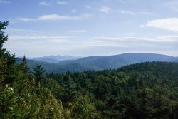
Day 3 was mellow, but held a nice view atop West Kill Mountain, the rest was easy gentle sloping down to the car.
-1.jpg")
Looking at the Burroughs Range in the distance(Wittenberg/Cornell/Slide left to right), which I did back at the end of July.
What always strikes me about the Catskills is how rapidly it can change from dense, hardwood forests into Boreal. It always catches me by surprise, and I am very fond of it. I had a great time, and look forward to being back when the leaves start to go at the end of the month.
Normally I'll do a big bad out west hiking trip in late summer early fall. Not this year, says 2020. However, A blessing of COVID has been learning to appreciate my more local surroundings, and I have been getting out a lot more frequently than I normally do. A friend and I had originally planned this hike as part of some leg stretching/training for a burlier Wind River route, now it will be just one of many shorter trips we have done, or will do, this season. The Devil's Path traverses a bunch of 3500'ers here in the Catskills, and boasts 18000 feet of vertical change over 25 miles. We planned it as a 3ish day, 2 nighter so we didn't have to suffer through the climbs with speed.
First, we had to shuttle vehicles, dropping the car at our ending trailhead, and doubling up on my friend's motorcycle with full packs 40 minutes back to our starting location. No photos of that, but it was my first time riding a bike for more than a short trip, and I'm ready to buy one. But I digress... By the time we had made it up from the city and shuttled vehicles, it was 5PM. We booked it up Indian Head, and made it to a shoulder of Twin, actually finding a solid dry campsite in the pitch dark with a fire ring already made. Excuse some of the photos, I didn't notice my clear filter had a huge smudge.
View of the Catskill Escarpment from Indian Head.
Looking south from Indian Head.
Sunset from col b/w Twin & Indian Head.
The next day, we climbed Twin to the summit, Sugarloaf, Plateau, and SW Hunter. The rough thing about the Catskills and this route in particular is that you almost always drop to the fall line between each and every peak. In addition, whoever designed these trails in the first place decided to attack the mountains from what seems like the steepest, most direct route possible, over rocks, thick roots, through notches or unneccessary(but fun) Class 3 scrambles, and in the general spot that water wants to flow. It is tough going, but I was glad of the decision to take this over 2.5 days, instead of an overnight. Made pacing more difficult than sufferfest. We were also lucky in that recent rains made what can sometimes be a very dry route into one with a lot of water, making it so we didn't have to carry more than a liter or two at a time. I was trying AM drops for the first time after years of using a gravity filter, and I liked it a lot.
From Twin looking at Sugarloaf
Cave on Twin
Literally every Catskills ascent.
Made it down to Diamond Notch falls and forgot to snap a pic due to the usual rush to find a campsite when it's getting dark. Found a nice campsite just far enough away from the creek to be mostly legal. 14 miles and 4500ft of elevation.
West Kill below Diamond Notch falls.
Day 3 was mellow, but held a nice view atop West Kill Mountain, the rest was easy gentle sloping down to the car.
Looking at the Burroughs Range in the distance(Wittenberg/Cornell/Slide left to right), which I did back at the end of July.
What always strikes me about the Catskills is how rapidly it can change from dense, hardwood forests into Boreal. It always catches me by surprise, and I am very fond of it. I had a great time, and look forward to being back when the leaves start to go at the end of the month.