Bill
.
- Joined
- Jan 17, 2012
- Messages
- 991
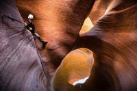
Our day began with a 6:30am start at the trailhead near checkerboard mesa. It was only 38° and the ground was wet from the previous night's storm so I packed my John just in case. We made great time up over the pass and soon we were standing above the first rappel looking at the dry sandy bottom down below. We rapped off a chockstone down into the tree filled slot and soon found knee deep water. We encountered a few more pools as we descended with the deepest being the in the upper arch room where it was about belly button deep.

First Rap by Summit42, on Flickr

Big log in Misery by Summit42, on Flickr

Misery Slot by Summit42, on Flickr

The Arch Room by Summit42, on Flickr

Tyler in Misery by Summit42, on Flickr

Fat Mans Misery by Summit42, on Flickr

All Smiles by Summit42, on Flickr
After the last rap we entered the deep dark narrows in the lower grotto and we were pleasantly surprised to find the the sulphur pool wasn't a swimmer like it was last fall. We were able to skirt around the edge where it was only knee deep then stopped for a few photos in the dark. I didn't take any photos in this section last time so I made special efforts to break out the tripod and shoot some long exposure panoramas.

Grotto Arch by Summit42, on Flickr

Leaving the Grotto by Summit42, on Flickr

Last slot in Fat Mans Misery by Summit42, on Flickr
The water in Parunuweap was low and clear so we hiked down to the spring near the Powell Plaque exit and had lunch. The plan was to hike down to Labyrinth falls but the forecast was for thunderstorms at 12. At 12:30 dark clouds moved in from the east and we heard the first clap of thunder when we were 1/3 of a mile below the plaque so we called it and headed back.

Parunuweap Canyon by Summit42, on Flickr
The exit climb was steep but the wind, thunder, and light rain made the hike out very nice. We did make one mistake worth noting. On one of the slick rock patches not from the campsite at the top of the Fat Mans Gully exit we took the wrong path that was well worn and had very recent footprints. We rolled with it and soon noticed we were way too close to the rim on the canyon when we were looking down on the confluence of the east and west forks. We decided to keep going to see where it ended up because we still had plenty of time to backtrack if needed. The trail ended up spitting us out back in Misery just below the first rap and slot section. We bypassed the slot on the right side (looking up canyon) and were soon at the base of the slick rock dome working our way back up as the rain drizzled down. I'm very interested in using this route in a future backpack trip where I will actually reach Labyrinth falls with my wife later this year. Anyways, we wrapped things up in 9.5 hours and my wetsuit never left my pack.
Featured image for home page:


First Rap by Summit42, on Flickr

Big log in Misery by Summit42, on Flickr

Misery Slot by Summit42, on Flickr

The Arch Room by Summit42, on Flickr

Tyler in Misery by Summit42, on Flickr

Fat Mans Misery by Summit42, on Flickr

All Smiles by Summit42, on Flickr
After the last rap we entered the deep dark narrows in the lower grotto and we were pleasantly surprised to find the the sulphur pool wasn't a swimmer like it was last fall. We were able to skirt around the edge where it was only knee deep then stopped for a few photos in the dark. I didn't take any photos in this section last time so I made special efforts to break out the tripod and shoot some long exposure panoramas.

Grotto Arch by Summit42, on Flickr

Leaving the Grotto by Summit42, on Flickr

Last slot in Fat Mans Misery by Summit42, on Flickr
The water in Parunuweap was low and clear so we hiked down to the spring near the Powell Plaque exit and had lunch. The plan was to hike down to Labyrinth falls but the forecast was for thunderstorms at 12. At 12:30 dark clouds moved in from the east and we heard the first clap of thunder when we were 1/3 of a mile below the plaque so we called it and headed back.

Parunuweap Canyon by Summit42, on Flickr
The exit climb was steep but the wind, thunder, and light rain made the hike out very nice. We did make one mistake worth noting. On one of the slick rock patches not from the campsite at the top of the Fat Mans Gully exit we took the wrong path that was well worn and had very recent footprints. We rolled with it and soon noticed we were way too close to the rim on the canyon when we were looking down on the confluence of the east and west forks. We decided to keep going to see where it ended up because we still had plenty of time to backtrack if needed. The trail ended up spitting us out back in Misery just below the first rap and slot section. We bypassed the slot on the right side (looking up canyon) and were soon at the base of the slick rock dome working our way back up as the rain drizzled down. I'm very interested in using this route in a future backpack trip where I will actually reach Labyrinth falls with my wife later this year. Anyways, we wrapped things up in 9.5 hours and my wetsuit never left my pack.
Featured image for home page:

