Short backpacking trips in the Escalante/Boulder area

Nick

-
.
Joined
Aug 9, 2007
Messages
12,951
The trip to Sand Creek over the weekend was awesome. This weekend I need something similar. Enough water to avoid packing it all in, dog-friendly, 8-15 miles, and of course beautiful. I'm thinking something else around Boulder & Escalante. Any suggestions? What about the canyons east of Hwy 12 and north of the Escalante? Boulder Creek, Deer Creek, Horse Canyon, Wolverine, etc. Anything but The Gulch!:eek: (those who attended the trip over the weekend know why :lol:)
 
I've backpacked in north chop rock. First part is dry but where it narrows up you will find some water/springs. It is off the wolverine petrified loop road.
 
The trip to Sand Creek over the weekend was awesome. This weekend I need something similar. Enough water to avoid packing it all in, dog-friendly, 8-15 miles, and of course beautiful. I'm thinking something else around Boulder & Escalante. Any suggestions? What about the canyons east of Hwy 12 and north of the Escalante? Boulder Creek, Deer Creek, Horse Canyon, Wolverine, etc. Anything but The Gulch!:eek: (those who attended the trip over the weekend know why :lol:)

I must have missed that part. What's wrong with The Gulch?
 
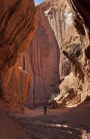
Was it worth it? Like how much beautiful canyon like that do you get before it gets technical? That looks awesome!

Ok to be honest we were on top of the choprock plateau. He knew of a secret route to the top of the circle cliffs and we stayed up on top. The last day on our way back out we took a quick side trip further up canyon. I dont think there are any technical parts to North Choprock. It is the south side that has the technical stuff. If you follow choprock all the way down you would eventually meet up with the escalante. We were north of the escalante. Our trailhead was off of the wolvering (I could be wrong but I think Jammer knows as if I recall one of his treks he exited the canyon country through north choprock) Our trailhead wasnt on hole in the rock but rather near the wolverine petrified wood natural area. THis is off the burr trail and the wolverine loop road. I know we drove past a chris mcandless bus (apparently he stayed there once and now all the worshippers make it a type of pilgramage to see it)


Was it worth it....Ya I think it would be. We turned around right when things were getting interesting. I will look up some other TR's I have seen of the area. There isnt very much information about this canyon so that is good!
 
* he being an older guy we were backpacking with. He was extremely knowledgeable and has spent as much if not more time in those canyons as anyone I have ever met.
 
Heya --

Yep -- I did Choprock on my first big hike. It's really nice -- maybe my favorite canyon on the east side of the Escalante. You could easily make a loop by going down Chop, (check out Neon), then back up Silver Falls Canyon. From the bottom, the hikable Choprock is "left", "right" "left" -- I can map it out if needed. There's nothing more technical than climbing over an occaisional boulder. No real springs, but several outbreaks/potholes of water along the way. Scattered petrified wood and colorful chinle hills near the top, great narrows and tapestry walls near the bottom. Silver Falls is not as great, but still a nice canyon. There's one reliable spring near the middle -- though it's a little bit up a side drainage.

I'll can post more later.

ALSO -- Boulder Creek is awesome as well, though water might be a little tricky/cold right now. The slickrock between Boulder and The Gulch is nice too.

I'm doing Little Death Hollow next month -- anxious to see how it stacks up to these canyons.

- Jamal
 
I would love it if you could map something out, Jamal. Or give me a day and I'll map it out and you can tell me how far off I am. :)

Does anyone know if there would be any water in the Little Death-Horse-Wolverine Loop?
 
The LDR/Wolverine loop might be better for your timeframe. I don't know the #s off the top of my head, but I'm guessing that that loop is approx 15 miles and the Choprock/Silver Falls loop is closer to 25-- w/o the side trip down to Neon.

I'm curious what's up with The Gulch too! BTW -- you can walk the ridge just east of The Gulch down to the King Bench area and then over to Narrows of Boulder Creek. Then you could go back the same way or up Deer Creek -- or the dreaded Gulch (definitely not the best part.)

Ok, back on Choprock though, here are a few quick pics...

Very top of Choprock North:
23_chop_top.jpg


The bus off the Moody Road:
24_the_bus.jpg

Art at bottom of Choprock (there's a huge panel):
23_petroglyphs.jpg

Middle of Chop:
23_choprock4.jpg

23_choprock3.jpg

Narrows of Chop:
23_choprock5.jpg


- Jamal
 
Yes, the Little Death-Wolverine loop is just a bit over 15 miles, perfect for an overnighter. Have you been through there? What was the water situation? I've read that there are a few springs/seeps that should work.
 
All that water could suck if it wasn't really warm out. Or maybe there would be no water at all?

I've never been through there, but I seem to recall SOMEWHERE that one section that commonly has pools can be avoided via short rim route. Not sure if that was from Kelsey or Allen, but it's stuck in my head for some reason.

I can't recall ever seeing photos with that much water. Last year was a pretty wet year though, right?

- JG
 
I think I'm losing my mind. Didn't someone post on here somewhere that there is a pretty reliable spring right at the confluence of Little Death Hollow and Horse Canyon? Or did I read that somewhere else? Does anyone know for sure?
 
Again... I haven't been there, but my research shows...

Two small springs high above the canyon on th east wall north of confluence of LDH and Horse. Old pipe runs down to the confluence (but I've read it doesn't flow.) But, surface water is common in the area around the confluence. Kelsey states this and you can actually see the water and extra vegetation via Google Earth. Panoramio photos also show surface water here.

It may not be the crystal clear spring water, but I don't think you will go thirsty. And... worst case scenario you are just over 2 miles from the Escalante.

Curious to hear your report to prep me for my hike. ALSO -- if by any chance you spot ANY water sources near the TH I'd love to know about them!

- Jamal
 
Silver Falls/Choprock Loop or any of those Circle Cliffs canyons. perfect time of year for that area.
Boulder Creek, not so much. cold, a lot of in the water wading & the lower section has swimming and waist deep wading. Deer Creek would be ok, but still lots of wading in cold water. it's possible to hike down east of the towers and domes next to Deer Creek though, and once below them, there is access to the creek below the Liston tanks.
Also, Boulder irrigation is not turned on yet, so the flow will be higher than a little bit later in the season in Boulder Creek.
 
ibenick , I haven't done much hiking in the lower Circle Cliffs yet, just a bit of the upper end of Wolverine.
From everything that I've heard, the Little Death Hollow/Wolverine loop is awesome.
Our secondary choice when we chose to do Egg Canyon was a Silver Falls / Choprock loop.
One of my friends can't stop raving about Choprock.
I think you'd be happy with either. if the LDH/Wolverine loop is calling you, i say go for it.
 
Back
Top