Thinking about this Wind River Route.

Hiker Seth

Member
Joined
May 15, 2019
Messages
90
I would do it in a clockwise manner, putting the hammer down day one to get closer to the good stuff. Last year I did Elkhart to upper Cook lake in a day and had plenty left in the tank, so I think it's within reason. I may go up the Rainbow Lake trail instead of looping around to Middle Fork from the bottom of the valley, and I may do Spearpoint instead of Loch Leven based on fishing intel. Remove the satellite layer to see the route better.

Gonna make a decision on this or the Beartooths by the end of July. Thoughts or feedback?

Edit: Based on current flight prices ($1000 to Montana and back vs FREE to SLC) I'm heading to the Winds. Route has been modified to fit new time constraints. Love that it shows up in real time here.


<iframe width="100%" height="500px" src=" Click here to view on CalTopo"></iframe>
 
Last edited:
Looks like an awesome route. Can't speak much as to the feasibility, but it definitely looks like your off-trail portions should go, based on the topo and some other reports I've read elsewhere. That first day will be pretty dang long, but the terrain should make it so it's not too difficult. The miles from Big Sandy to Washakie Creek fly by. Not much elevation change per mile. So I'd guess it stays the same as you continue on since the terrain looks pretty similar. And I love how quiet and calm the meadows are on the Fremont Trail above Marms Lake. In spite of more dramatic scenery to the east, that may have been the highlight of my trip to the area last year.

I'm headed to Big Sandy and onto parts of this route (snow on the passes permitting) in two days, so I can weigh in a bit more when I get back. Really hoping we have time for the East Fork Lakes and good enough conditions to make it over Hailey Pass. We shall see.
 
Looks like a fun route. It is all doable but you have to know better about the daily mileage than we do for you.
 
Looks good.... couple suggestions, been over a large portion of your route. Spwearpoint lk instead. At the saddle between Raid and Bonneville pk.... go a hard north, you can get down thru the small saddle to Bonneville, saves some elevation. Go all the way to Sheila lk before going up, some large rocks but easily doable thru that saddle. Camp by Shelia...nicer. Noel lake is neat.. (goldens), Lee lk has goldens. Id go out by Rainbow....but I like offtrail. Could start at Sweetwater TH instead....some neat, not traveled much till Ice lks. Could do Wind River pk on the way.
 
Looks good.... couple suggestions, been over a large portion of your route. Spwearpoint lk instead. At the saddle between Raid and Bonneville pk.... go a hard north, you can get down thru the small saddle to Bonneville, saves some elevation. Go all the way to Sheila lk before going up, some large rocks but easily doable thru that saddle. Camp by Shelia...nicer. Noel lake is neat.. (goldens), Lee lk has goldens. Id go out by Rainbow....but I like offtrail. Could start at Sweetwater TH instead....some neat, not traveled much till Ice lks. Could do Wind River pk on the way.

Thanks, Bob. I think Sweetwater TH would make the route far too long for my time window. Appreciate the feedback on the route, lakes, and fishing. Have you been to Mendarrin lake?
 
Looks like an awesome route. Jealous. Not sure what snow will be like in the higher parts of your route, but you're obviously keeping your eye on that.

  • Long first day, but I can't argue against the logic to just get done with that section. =)
  • I though Middle Fork Boulder Creek was nice - camped along there once (on granite). Haven't been by Rainbow.
  • Could skip Loch Leven, although I think we caught some bows out of there. (Maybe check out Spearpoint instead - I've never been to it but I've always wanted to and Bob suggested it).
  • The route from Valentine to Cathedral might be brutal. One time we tried to day hike UP that (from Cathedral) and it was a boulder-hop-fest and we gave up part of the way (granted I was with a pretty weak group). There was a mama and cub grizz in the area that day, too.
  • I thought Medarrin was cool.
  • I love approaching the Cirque from the east. Very cool.
  • Consider adding Black Joe, Clear, Deep, Temple? Nice little loop/area.
What's the mileage and projected number of days/nights? And what dates? (Edit: answered my own question about how many days/nights).

Good luck!
 
Last edited:
Thanks, Bob. I think Sweetwater TH would make the route far too long for my time window. Appreciate the feedback on the route, lakes, and fishing. Have you been to Mendarrin lake?
Nope.... Halls lk and Europe lks are good fishing... A little north. Halls less people than Europe. Yeah Sweetwater would be longer .... But not a fan of Sandy or the Cirque
 
@Mike K Thanks for the intel on Cathedral. I went back and re-read Pallister's description. Might be more than I want to tackle alone.

@Bob I haven't seen the Cirque so I figure I need to at least once.
 
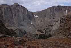
As to cathedral valley - the decent can be made easier by rounding Mount Chauvenet to the north and dropping down to the west of the intermittent creek flowing to Cathedral Lk. I have not done the direct route (see pics below) to the intersection due to snow. Lots of big rocks and dense vegetation around Cathedral Lk. There is an easy route that sometimes appears.
The climb out of Mendarrin appeared to have some sloping ledge that was all wet when I was there. An alternate is to gain Lizard Head by travel east of Cook Lk then ascend the ridge to the south and follow west.

654A1A5B-6588-4F32-9CCA-89D77A9B83C5.jpeg


4FCEC1CB-6BAF-4B82-8916-23D29AB00E01.jpeg
 
As to cathedral valley - the decent can be made easier by rounding Mount Chauvenet to the north and dropping down to the west of the intermittent creek flowing to Cathedral Lk. I have not done the direct route (see pics below) to the intersection due to snow. Lots of big rocks and dense vegetation around Cathedral Lk. There is an easy route that sometimes appears.
The climb out of Mendarrin appeared to have some sloping ledge that was all wet when I was there. An alternate is to gain Lizard Head by travel east of Cook Lk then ascend the ridge to the south and follow west.

View attachment 79463


View attachment 79464

That is some class A photo intel. Thank you very much.
 
Yep, I have pictures from that day that I can point you to if you want to see them.
Appreciate the thought but I have modified the route to skip Mendarrin due to my trip losing a day. Probably just go over Lizard Head plateau instead.
 
Back
Top