Udink
Still right here.
- Joined
- Jan 17, 2012
- Messages
- 1,692
This was kind of a long drive for such a short hike. I went down the Tidwell Draw road in the Swell to the San Rafael River, then hiked into Thompson Hole to find a geocache and some petroglyphs. Thompson Hole is an abandoned river meander where the San Rafael cuts through the Reef, and there's an old bulldozed road leading into the bottom. There's a new (within the past few weeks) "No Vehicles" sign just before the road descends, however, so I parked there and walked the rest of the way. I hiked about two miles and spent two hours looking for rock art in the area. Afterward I intended to hike a couple of small drainages in the San Rafael Reef north of there, but in the nearly-100-degree heat I wasn't feeling up to it.
Thompson Hole panorama

The Jeep parked on the San Rafael Reef above the river

WSA sign before the road descends into Thompson Hole

At first I thought I was seeing Indian ruins, but these are just rock walls to keep cattle from wandering

Sharpening grooves

Grinding marks

San Rafael River

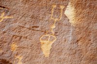
Petroglyphs


Cowboy glyphs

More petroglyphs at a second panel


Exploring a small side-canyon

Climbing out of Thompson Hole

It was only 91 degrees when I finished hiking, but I saw a high of 98 on the drive out

Dust on the back of the Jeep

Full photo gallery:
https://picasaweb.google.com/Dennis.Udink/ThompsonHole
Featured image for home page:

Thompson Hole panorama

The Jeep parked on the San Rafael Reef above the river
WSA sign before the road descends into Thompson Hole
At first I thought I was seeing Indian ruins, but these are just rock walls to keep cattle from wandering
Sharpening grooves
Grinding marks
San Rafael River

Petroglyphs
Cowboy glyphs
More petroglyphs at a second panel
Exploring a small side-canyon
Climbing out of Thompson Hole
It was only 91 degrees when I finished hiking, but I saw a high of 98 on the drive out
Dust on the back of the Jeep
Full photo gallery:
https://picasaweb.google.com/Dennis.Udink/ThompsonHole
Featured image for home page:

