Trip first week of April 2021 Southern UT/Anywhere AZ - Death Hollow, Coyote Gulch, or other suggestions?

Jimbo

New Member
Joined
Mar 23, 2021
Messages
4
Hello everyone!

I am currently planning on a 2 night backpacking trip the first week of April (April 3-5), and I was hoping I can get some suggestions from others. Currently, the three options on the table are Death Hollow, Coyote, Gulch, or Rainbow Bridge. I'm also open to suggestions anywhere around Arizona as we will be coming from Flagstaff, AZ.

I was initially planning on Deaths Hollow (start at Escalante --> up BMT --> down Maime Creek --> up Escalante River); however, I'm second guessing that route due to cold water crossings with weather being in low 60's. In general, how far might we expect to have to remain in the water during the hike? I am aware of the tricky deep crossing spot where you have to try to remain on the ledge, and the heavy poison ivy. I will plan to check on water levels with the local forest service office prior to the trip.

Lastly, I had a question regarding when spring "springs" in the canyons in southern Utah. Does anyone have any idea when when greenery starts popping up in Death Hollow or Coyote Gulch?

Thanks!
 
I am currently planning on a 2 night backpacking trip the first week of April (April 3-5), and I was hoping I can get some suggestions from others. Currently, the three options on the table are Death Hollow, Coyote, Gulch, or Rainbow Bridge. I'm also open to suggestions anywhere around Arizona as we will be coming from Flagstaff, AZ.

FYI- Pretty sure backpacking on the Navajo Nation (Rainbow Bridge) is still closed because of COVID: https://navajonationparks.org/
 
Death Hollow way easier going down canyon..... And yes a lot of in the water. I'd say Coyote gulch best bet..in at jacob hamblin.

Cedar Mess area
 
You'll be in water varying from ankle deep to waist deep for probably more than half the time you're in Death Hollow. And then you have to cross the Escalante several times as well. May still be worth a shot if it's going to be sunny, but I'd probably do something different, like Bob suggested.
 
Hello everyone!

I am currently planning on a 2 night backpacking trip the first week of April (April 3-5), and I was hoping I can get some suggestions from others. Currently, the three options on the table are Death Hollow, Coyote, Gulch, or Rainbow Bridge. I'm also open to suggestions anywhere around Arizona as we will be coming from Flagstaff, AZ.

I was initially planning on Deaths Hollow (start at Escalante --> up BMT --> down Maime Creek --> up Escalante River); however, I'm second guessing that route due to cold water crossings with weather being in low 60's. In general, how far might we expect to have to remain in the water during the hike? I am aware of the tricky deep crossing spot where you have to try to remain on the ledge, and the heavy poison ivy. I will plan to check on water levels with the local forest service office prior to the trip.

Lastly, I had a question regarding when spring "springs" in the canyons in southern Utah. Does anyone have any idea when when greenery starts popping up in Death Hollow or Coyote Gulch?

Thanks!
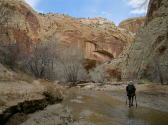
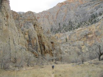
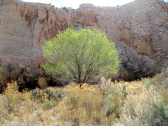
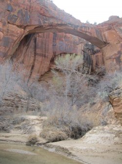
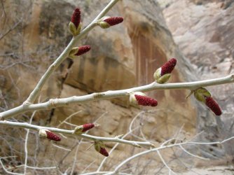
I don't know about this year in particular, but we hiked the BMT and Escalante River in early April 2018. We were on the river April 5 and 6, and spring was just starting. Here are a few pics - some have no green, others have tiny hints of green, and one has a tree way ahead of the others. I found that fascinating!

30531526_10216242911935118_2084172467097567232_o.jpg30571843_10216242904654936_8605654795073617920_o.jpg30530449_10216242910815090_2542362773690515456_o.jpg30531345_10216242908015020_3155222334445453312_o.jpg

30531179_10216242901414855_5588401971410239488_o.jpg30623778_10216242911495107_6565200701297786880_o.jpg30531426_10216242909055046_5078237393690034176_o.jpg30571750_10216242901254851_4014045541141839872_o.jpg
 
I don't know about this year in particular, but we hiked the BMT and Escalante River in early April 2018. We were on the river April 5 and 6, and spring was just starting. Here are a few pics - some have no green, others have tiny hints of green, and one has a tree way ahead of the others. I found that fascinating!

View attachment 97010View attachment 97007View attachment 97009View attachment 97003

View attachment 97005View attachment 97008View attachment 97006View attachment 97004
Janice, thanks for the information on what the plants were doing! That one tree was pretty excited for spring, huh? :)

What was your experience like with the water levels and temperatures?
 
I did Coyote (JH-confluence-Crack) as a day hike. Unless you're adding something on or really like going slow 2 nights is probably one too many.
 
Janice, thanks for the information on what the plants were doing! That one tree was pretty excited for spring, huh? :)

What was your experience like with the water levels and temperatures?
When we were there, the temps probably ranged from daytime highs in the 60s and nighttime lows around 30. My water had little chunks of ice floating around in it in the morning!

For water level info, I like looking at this: https://waterdata.usgs.gov/ut/nwis/uv?site_no=09337500 You can change the dates to see info at different times. There's a gauge in the Escalante River right where the Boulder Mail Trail meets the river. I have friends who will be there next week, so I was helping them by comparing current and past data. It's pretty similar now to when we were there. You can call the Escalante visitor center and see what they know about water levels and sources.

Whatever you decide, hope you have a great trip!
This is great info - thank you!
 
Back
Top