Uintas: Amethyst to Middle Basin off-trail pass?

JoshuaDyal

Member
Joined
Mar 16, 2015
Messages
186
I'm thinking from the topo that just to the north of Ostler Peak, in that "bight" in the mountain just south of Ostler Lake, that it would probably be pretty easy to crest that ridge and get to Middle Basin without having to go all the way around on the trail.

Has anyone done this, and if so, can you comment on the viability/easiness of that route?
 
That would be an awesome route. I can't comment on the feasibility of it, but am curious myself.
 
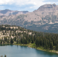
Looks doable in the sense that you should be able to get around the cliffs. There's a pretty good band there toward the bottom of the talus. Personally I'd rather go around the mountain on the trail than go up and then down 1000' of giant boulders at the angle of repose. That could be pretty unpleasant and dangerous. Here's a not great shot of the side you'd come down. Ostler to the right.

upload_2015-3-16_11-16-56.png
 
It might be better to go at it from Middle Basin into Amethyst if you try it. It would be easier going up that big ass slope than down, and the other side doesn't look quite as bad. Definitely leave the dog home on that trip!
 
Doable- probably, but why? If you want to get there fast, you'll probably be faster just sticking with the trail. By the time you factor in route finding, elevation change, and boulder hopping any gains you've made by cutting distance have evaporated.

Now if you're looking at tackling it "because it's there" then by all means go for it!
 
Also because of great views from the top of the ridge. But yeah; the pictures of the slope I'd have to scramble over look less appealing than the lines on the topo did.
 
Doable- probably, but why? If you want to get there fast, you'll probably be faster just sticking with the trail. By the time you factor in route finding, elevation change, and boulder hopping any gains you've made by cutting distance have evaporated.

Now if you're looking at tackling it "because it's there" then by all means go for it!
Agreed. When I was with a group that did Kings peak, they decided to jump off the trail to Andersen Pass and instead, head straight up the boulders to the ridge just below the summit. Yes, it saved about a mile and half to two miles, but in hind sight, I think I could have beaten them to the same point on the ridge with much less stress on my lungs by sticking to the more gradual trail up Andersen and then do the easier boulder hoping along the ridge.

Since then, if there is an established trail to the same destination, I will almost always take the trail, especially if it means only a couple extra miles because it will generally be safer, easier to move over, and thus require less energy and often less time in the long run.

However, if someone wants challenge themselves, get some views that wouldn't otherwise be obtained, or simply just just add to their adventure, then go for it.

Edited for some typos.
 
If I were going for the view, I'd just assume bag Ostler.

I've heard the climb up Ostler is pretty rough. I'd be more inclined to do Spread Eagle from near Faxon Lake and get more or less the same view.
 
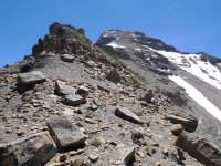
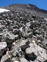
The view from the Ostler's ridge and summit were great. I'd highly recommend bagging this peak if you're at Ostler Lake. The hike up wasn't a cake walk but I don't remember any scary scrambling or anything. I'll post a few shots from our route taken from Lane's Ostler/Amethyst trip page (which includes the GPS track of our route):


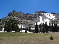
Looking up at our route and Ostler Peak from near Ostler Lake
Ostler from the bottom.jpg


A nice view of Lake BR24 (or whatever it's called)
Oslter looking down at the B lake.jpg


A view of the ridge line looking towards Ostler Peak
Ostler Ridge Line.jpg


Grinding through some boulders and rocks
Ostler Ridge Scrambling.jpg


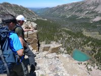
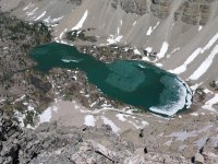
One of the payoff views from the top. This is looking down at Amethyst Lake.
Ostler View of Amethyst.jpg The
 
Last edited:
I've heard the climb up Ostler is pretty rough. I'd be more inclined to do Spread Eagle from near Faxon Lake and get more or less the same view.

Spread Eagle Peak (via Faxon) was cool as well but I liked Ostler better.
 
One of the payoff views from the top. This is looking down at Amethyst Lake.
ostler-view-of-amethyst-jpg.27934
The

Now that's the view I'm talking about. ;) Bad ass.
 
Nice pics! Thanks!

Y'all have convinced me; the pass from Amethyst to Middle isn't worth it. However, I know that folks have gone over the ridge from Allsop to Priord/Norice (in fact, I think I first saw that on a Google search that brought me here!). What about crossing some of the other north-side basins? Dead Horse to Allsop? Priord to Amethyst? There aren't any good ways to go on-trail from those without adding many miles of backtracking up fairly narrow canyons.
 
Upper Red Castle > Oweep = doable
Dead Horse > Allsop = doable
Priord > Rock Creek = doable
Priord > Amethyst = haven't heard of it being done
Amethyst > Helen = doable
Middle Basin > Hwy 150 = doable
West Basin > Hwy 150 = doable
 
Back
Top