Kullaberg63
Member
- Joined
- Mar 6, 2014
- Messages
- 619
Late start, 1 pm, and building clouds made for a hasty gait up the talus slopes of this prominent La Sal peak.
We parked at the end of the Gold Basin spur road. A faint user trail led down to and crossed the creek, whereafter we were on our own. A giant avalanche swath of mostly large boulders provided a scramble route up to a shoulder before Tuk No, a respectable peak in itself and part of the sweeping north west ridge of Tukuhnikivatz.
The upper part of most La Sal giants are merely loosely stacked talus like blocks, steep and unstable. Until one settles to this fact, and know it's simply part of the experience, these peaks can be a little trying. Especially when it comes time to head down.
Anyway, once on the summit of Tuk No, we became aware of numerous thunder cells swiftly moving across the middle altitude mesas. Rumbling ensued. From here the route commitingly descends to an expansive saddle before climbing another 800' to the top. With the weather shaping up like this we decided to split the group: Sonja and our short legged mutt, straining visibly in the large blocky terrain, would briefly enjoy the incredible scenery before turning around and retracing the route. Bjorn and I would run before the storm over the summit and hopefully find a snow chute further east to quickly glissade down, reaching the comparative safety of the krummholz in upper Gold Basin. From here we knew we would face a circuitous, but lovely subalpine bushwhack back around to the start.
To shorten an already lengthy tale, let me just mention that that was exactly how it panned out and we all rejoined at the van for dinner.

The beginning, with the route ascending the obvious gully thingy.

Talus!

Plenty of snow left, if one seeks it out.

The upper slopes of Tuk No, the satellite peak to Tukuhnikivatz

Beyond the angle of repose!

Gold Basin fringed by peaks. Our descent gully is visible if one know where to look!

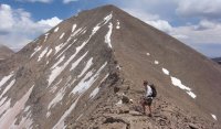
On the saddle. The final climb obvious.

Summit. We had plans to pitch a homemade mid for testing, but lightning to the west forced a swift retreat.

Dinner time!

image by kullaberg631, on Flickr
Featured image for home page:

We parked at the end of the Gold Basin spur road. A faint user trail led down to and crossed the creek, whereafter we were on our own. A giant avalanche swath of mostly large boulders provided a scramble route up to a shoulder before Tuk No, a respectable peak in itself and part of the sweeping north west ridge of Tukuhnikivatz.
The upper part of most La Sal giants are merely loosely stacked talus like blocks, steep and unstable. Until one settles to this fact, and know it's simply part of the experience, these peaks can be a little trying. Especially when it comes time to head down.
Anyway, once on the summit of Tuk No, we became aware of numerous thunder cells swiftly moving across the middle altitude mesas. Rumbling ensued. From here the route commitingly descends to an expansive saddle before climbing another 800' to the top. With the weather shaping up like this we decided to split the group: Sonja and our short legged mutt, straining visibly in the large blocky terrain, would briefly enjoy the incredible scenery before turning around and retracing the route. Bjorn and I would run before the storm over the summit and hopefully find a snow chute further east to quickly glissade down, reaching the comparative safety of the krummholz in upper Gold Basin. From here we knew we would face a circuitous, but lovely subalpine bushwhack back around to the start.
To shorten an already lengthy tale, let me just mention that that was exactly how it panned out and we all rejoined at the van for dinner.

The beginning, with the route ascending the obvious gully thingy.

Talus!

Plenty of snow left, if one seeks it out.

The upper slopes of Tuk No, the satellite peak to Tukuhnikivatz

Beyond the angle of repose!

Gold Basin fringed by peaks. Our descent gully is visible if one know where to look!

On the saddle. The final climb obvious.

Summit. We had plans to pitch a homemade mid for testing, but lightning to the west forced a swift retreat.

Dinner time!

image by kullaberg631, on Flickr
Featured image for home page:

Last edited:
