Duke
Mountain Carver
- Joined
- Feb 19, 2012
- Messages
- 382
I promised Nick some time ago that I would write up a TR on Spring Canyon, Capitol Reef (ever since I popped off about using ropes to get to the narrows in a former thread on this site). It just took me a while. And, I must admit that I have been trying to keep this place a secret. It is actually well known but few know just how awesome it is and fewer venture all the way through it. Not a technical canyon but I recommend you treat it as such for added awesomeness. Read on for details. It is a 10 mile long hike through a beautiful narrows/canyon area and well worth the trip. This TR is for the bottom section of Spring, accessed via Chimney Rock TH. Spring Canyon itself has about 20 extra miles above this section and I have never been there. This TR starts at the chimney rock trailhead in Capitol Reef and comes out about 8 miles further East on the highway so a shuttle will be needed. I have hitchhiked each time. Because hitching rides has been easy in Cap Reef I figure that I owe some karma and try to pay back when I see someone there needing a lift in the Park. This is how I once met an Aussie panhandler that just needed enough money to get to Seattle and somehow he would then be fine…, but, I digress and can share those details another time. This hike also requires a ford of the Freemont river as the very last thing just before getting to your vehicle. Since the end of the hike, the river ford, and your car staging area are all in one, it is easy to check the river conditions prior to starting. There is a pullout on the side of the highway near mile marker 83 that is just 60-80 meters or so “upstream” of where you will emerge to the highway edge after your hike. Park your 1968 Camaro there. I hitch with a sign that reads “only to trailhead” to try and demo that I am not looking for that last $25 to get me to Seattle, just a quick ride. One hot, June day we got a ride in a reefer truck and it was a good start. Also, this is a 10 mile hike but you should be ready for the equivalent to a 13 mile hike or so. Much of this is in sand and it really seems to add to the workout or at least it did for this old man. There is water from a spring about 6 miles (complete guess) in and it becomes less of an oil slicked, rotten swamp hole about ½ to 1 mile further down. The video shows one of the better water areas.
Starting at the chimney rock trailhead/parking area: there will likely be mucho cars at the trailhead, but don’t worry, they are all headed up for the lookout on Mummy cliffs or crossing the road to start the Sulfur Creek hike. Less than a mile into you trek you will come to a sign that splits the trail and sends the Mummy folks off on their own. That trail is a loop and one can take that and still end up in Spring canyon, but I recommend just staying you’re your trail, which is marked and shows the split to Spring Canyon. Follow the signs and once in Chimney canyon going down toward Spring the only directions you really need are to keep going down, including the juncture with Spring Canyon. Just follow gravity. Multiple large canyons join up during this hike but for us, it has always been clear where to go because we could see which canyon was a side canyon that went up and which was the main canyon that went down. A bottom up route may require some decision making to determine which is the main wash but top down has always been a clear, obvious path for us on this route. The most difficult part of this hike is the first part with the mummy cliffs loop trail forks and getting into the wash heading down to Spring but there are signs. About half way into this beautiful hike and one hits the start of the narrows. There are cairns marking an exit out of the narrows to a goat trail bypass on the left. See the pics below. There is one easy drop at a dry wash (see the video link) then one that I believe should be roped up for (see pic) and one so-so. None are very high. All will sometimes have stank mud/water at the bottom which unlike the water in Cap Reef’s slot canyons, does seem to be related to wet/dry year/conditions. Just mud the last time we were there and the Ranger told us that it has dried out considerably from the drought. Once again, the bypass can be taken instead and no ropes or downclimbing needed for that. The bypass joins up with the main wash after the narrows. One can take the bypass and after joining back with the main wash; head up from below and see much of the narrows. Either way it is certainly one of the best sections and should not be missed. At least one of the dryfalls I would call generally pretty tough to come bottom up, unaided though anyone used to freeclimbing may be able to? Probably worth the try. I couldn’t do it and I know I wouldn’t come down it freehand. All usually have the water/mud at the bottom and a slip….well..?
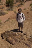
the canyon has plenty of petrified wood. Here is an example
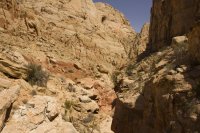
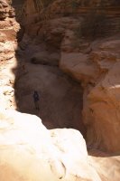
This is the bypass. Look on the left of this shot and you can see the goat trail in the dark, mars colored dirt.
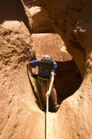
rapping at one of the dryfalls. a large mudslide poured in the bottom from the right side which is what looks like the bottom in this pic. There was a good rockpile anchor already set there by someone else that we used.
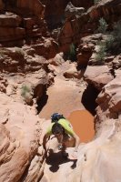
The so-so dry fall. One pic with water and one pic when there was just mud.
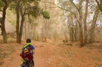
the last 3/4 mile or so is in the trees/brush as the trail approaches the river.
Featured image for home page:
Starting at the chimney rock trailhead/parking area: there will likely be mucho cars at the trailhead, but don’t worry, they are all headed up for the lookout on Mummy cliffs or crossing the road to start the Sulfur Creek hike. Less than a mile into you trek you will come to a sign that splits the trail and sends the Mummy folks off on their own. That trail is a loop and one can take that and still end up in Spring canyon, but I recommend just staying you’re your trail, which is marked and shows the split to Spring Canyon. Follow the signs and once in Chimney canyon going down toward Spring the only directions you really need are to keep going down, including the juncture with Spring Canyon. Just follow gravity. Multiple large canyons join up during this hike but for us, it has always been clear where to go because we could see which canyon was a side canyon that went up and which was the main canyon that went down. A bottom up route may require some decision making to determine which is the main wash but top down has always been a clear, obvious path for us on this route. The most difficult part of this hike is the first part with the mummy cliffs loop trail forks and getting into the wash heading down to Spring but there are signs. About half way into this beautiful hike and one hits the start of the narrows. There are cairns marking an exit out of the narrows to a goat trail bypass on the left. See the pics below. There is one easy drop at a dry wash (see the video link) then one that I believe should be roped up for (see pic) and one so-so. None are very high. All will sometimes have stank mud/water at the bottom which unlike the water in Cap Reef’s slot canyons, does seem to be related to wet/dry year/conditions. Just mud the last time we were there and the Ranger told us that it has dried out considerably from the drought. Once again, the bypass can be taken instead and no ropes or downclimbing needed for that. The bypass joins up with the main wash after the narrows. One can take the bypass and after joining back with the main wash; head up from below and see much of the narrows. Either way it is certainly one of the best sections and should not be missed. At least one of the dryfalls I would call generally pretty tough to come bottom up, unaided though anyone used to freeclimbing may be able to? Probably worth the try. I couldn’t do it and I know I wouldn’t come down it freehand. All usually have the water/mud at the bottom and a slip….well..?
the canyon has plenty of petrified wood. Here is an example

This is the bypass. Look on the left of this shot and you can see the goat trail in the dark, mars colored dirt.

rapping at one of the dryfalls. a large mudslide poured in the bottom from the right side which is what looks like the bottom in this pic. There was a good rockpile anchor already set there by someone else that we used.

The so-so dry fall. One pic with water and one pic when there was just mud.


the last 3/4 mile or so is in the trees/brush as the trail approaches the river.

Featured image for home page:

