Time to tear down Glen Canyon Dam?

Should Glen Canyon Dam be torn down?

  • Yes

    Votes: 30 78.9%
  • No

    Votes: 8 21.1%

  • Total voters
    38
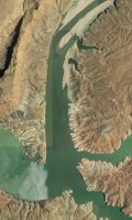
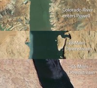
Much more silt accumulates in the shallows at the backs of canyons and where the rivers come in than in the lower/deeper parts. Too bad it isn't the other way around, the dam would already be inundated.
Hmmm interesting. I would have guessed you'd find huge deposits of sediment in the deeper areas, as there was more water on top of for he silt to settle on. You're saying the muddy water had already deposited its sediment load before it reached deeper areas of the lake?
 
That's correct, Larry. When spring runoff hits, the water will carry silt further down lake, dropping it throughout more of the reservoir, but the bulk of it drops where the rivers and washes hit the still water. And of those, nothing drops more than the Colorado. The north end up around Trachyte and White canyons is getting totally hammered with silt from it. As you move farther down lake and into the deeper parts, the water just gets more and more clear because the silt doesn't have any more flow to push it down there. When floods hit, all of the canyons contribute, of course, but nothing like the big rivers do.
 
the faster water moves the more silt it can carry. that's how the grand canyon was cut. so when water stops moving it drops it's load. any way. speaking of lake powell, and it's dropping silt, does any one know where the lake starts these days. where the river stops moving, and flat water begins.
 
I read recently that it's super shallow right up by White Canyon right now. The current google sat imagery (below) is actually pretty close to accurate. In those images (May 2013), the lake level was 3599. Right now it's 3591, so imagine 8' less. I'd bet that moved the mark pretty close to the mouth of Farley, the upper one in the bottom right of the below photo. White is the lower right.

start-of-powell.jpg
 
  • Like
Reactions: Ben
Hmmm interesting. I would have guessed you'd find huge deposits of sediment in the deeper areas, as there was more water on top of for he silt to settle on. You're saying the muddy water had already deposited its sediment load before it reached deeper areas of the lake?

It's all purely Stoke's Law. The more coarse sand (and any gravel) will drop very quickly in still water so almost all of that will be near the mouth of the river. The silt fraction takes a bit longer to settle and will be carried farther out into the lake. The clay fraction can be carried throughout-at least the finer end of it. However, you also get occasional mass movements under water which can redistribute the sediment in local areas.

Assuming the dam was breached or even if the water level was just lowered back to something close to the base level, all that sediment will again be heading downstream-to the next still water. From a geomorphic perspective, it would be very interesting to see what happens in the Grand Canyon under that scenario. It's almost guaranteed to produce some rather dramatic results in the short term.
 
One more sediment related graphic that I find to be really interesting...

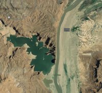
This is the Colorado up at Hite, the location of the now-very-dry Hite Marina. You can see the concrete launch ramp on the east side of the river. That big puddle on the left is the very end of North Wash which used to flow into the Colorado. What I take from this, is that so much sediment dropped right here that the bed of the river, and the areas around it, became significantly higher than the bottom of North Wash. I'm sure a lot of it would swirl in there and drop, but it makes sense that the bulk would drop right there along the main flow. Just imagine how much sediment buildup that must be to leave such a huge lake stuck in North Wash!
north-wash-sediment.jpg

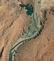
Zoomed out view for some perspective. At point the river had to have been much lower than the current bottom of North Wash, but look how long it takes to reach the reservoir now! That is a crap load of sediment! I find that to be pretty fascinating. Maybe someone else will too .
north-wash-sediment-2.jpg
 
I do wonder what short/long term changes would happen to the Grand Canyon without the Glen canyon dam
 
I do wonder what short/long term changes would happen to the Grand Canyon without the Glen canyon dam

The existence of the dam has not been great for the Grand Canyon. The lack of silt and flood waters coming through have washed away beaches and sand bars in a bad way. And where they stuck around, vegetation has moved in and taken over where it would have been wiped out by a periodic flood in the past. The last few years they have been doing controlled flood simulations where they open the gates at the dam and send a ton of water into the grand for like a week straight, in hopes of rebuilding some of those sand bars.

More info:
http://www.npr.org/2012/07/10/156566151/tensions-rise-with-plan-to-flood-grand-canyon

And one that also discusses the impact it has had on the fish habitat:
https://www.hcn.org/blogs/goat/are-...s-keeping-an-endangered-fish-from-flourishing
 
speaking of lake powell, and it's dropping silt, does any one know where the lake starts these days. where the river stops moving, and flat water begins.

I guessed wrong. I just found out that the silt is so thick that the river ends closer to the mouth of Trachyte right now. Crazy!

And even crazier, check out this post on Waynes Words, a popular fishing-centric Lake Powell forum:

http://www.wayneswords.com/index.php?option=com_kunena&Itemid=27&func=view&catid=8&id=92656

"I was up there about 3 weeks ago, and while we did not go up toward Farley (we were afraid), the section of river channel you would have to pass through to get there was what looked like a mild rapid, with riffles and foamy brown water. As you approach where the Colorado enters the bay, near the junction of White Canyon, there is a bar on the east side (where White Canyon begins). The Bathymetric map of the area showed it being something like 280 feet deep at full pool (as I remember) but it was only 30 feet deep, even though the lake has dropped 110 feet from full pool. The difference is all the sediment that used to settle out up around Hite, but now is transported much further down the River Channel, and has buried the area in silt."

By that math, there is sediment piled up something like 140' deep in that particular spot! :eek:

On a related note, this is an interesting article:
http://archive.azcentral.com/travel/articles/20131012glen-canyon-dam-lake-powell-future.html
 
Pretty interesting stuff! If what I've read about water in the west is correct, unless we all start making some drastic lifestyle changes right now, Powell and Mead will by dry in the next 20 years. It makes no sense to leave either dam up. The desert was never meant to withstand the massive populations it houses now. The number one thing that must be done is to get rid of lawns and landscape with rocks or native plants that don't need a lot of water to survive.
 
Resurrecting this old thread because I thought this story was relevant it:

https://www.sltrib.com/news/environment/2019/01/20/lake-powell-could-become/

Might be worth it's own thread, but yeah....it's been amazing to see how much the northern tip of LP has changed over the years. My first experience with LP ever, was when I was a teenager some 20 years ago and got to camp along the shores of Hite and got to experience wake-boarding and did some cliff jumping up in North Wash. The lake was quite full then with plenty of water to launch at Hite and boat all around there. Also got to spend a day hiking through White Canyon and the Black Hole over there at the time.
 
Thanks, Will. I've been watching the water levels of Powell and wishing I still had my boat this spring. It's on track to hit it's lowest point since 2005 when the floor of Cathedral in the Desert was revealed for the first time since filling. It's already close to the 2014 low that showed some of the floor. I need to figure out how to get out there this spring...
 
Thanks, Will. I've been watching the water levels of Powell and wishing I still had my boat this spring. It's on track to hit it's lowest point since 2005 when the floor of Cathedral in the Desert was revealed for the first time since filling. It's already close to the 2014 low that showed some of the floor. I need to figure out how to get out there this spring...
This is the minor downside to actually having some moisture...if it would have waited one more year we could have had some serious exposure down there ha! Still should be some good stuff to see.
 
Thanks, Will. I've been watching the water levels of Powell and wishing I still had my boat this spring. It's on track to hit it's lowest point since 2005 when the floor of Cathedral in the Desert was revealed for the first time since filling. It's already close to the 2014 low that showed some of the floor. I need to figure out how to get out there this spring...
Hike in......we did it last time.... Well you need some rope work too
 
Many of the places I'd like to go are not feasible to hike into unless you have a lot of time on your hands.
It's a day hike
 
I have wanted to take my canoe onto Lake Powell, stay close to shore. I have seen pics of canoes in the pool @ Cathedral. Maybe....
 
Back
Top